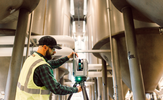
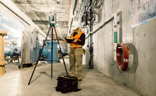
3D laser scanning
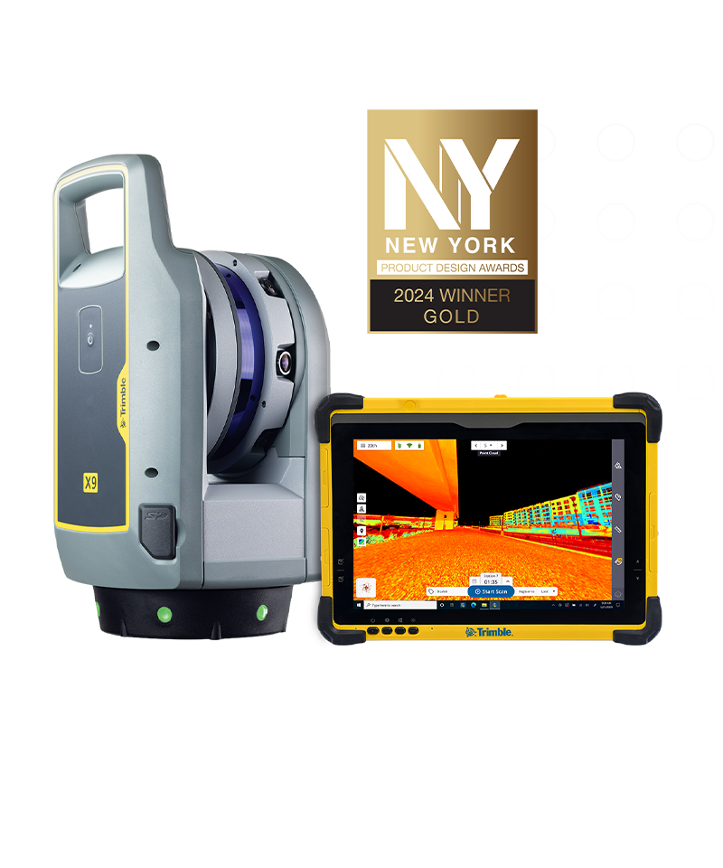
Trimble X9
The power to do more, on your terms.
The Trimble® X9 3D laser scanning platform leverages proven Trimble technology to deliver the range, accuracy, speed and sensitivity you need to do more. With flexible licensing plan options, choose the scanning functionality that fits your project needs.
Benefits and performance
A solution that best fits your needs
Customize your X9 with flexible configurations. Choose the model that fits your needs, from Core LT, Core to Premium, ensuring the perfect option for every project.
Proven innovations and simple workflows
Automatic calibration, self-leveling and Trimble Perspective software ensure scanner performance, easy setup and comprehensive in-field registration workflows.

Scan speed
Up to 1000 kHz
Scan range
0.6 m–150 m
Scan time
<1 min - 6 min
Features and capabilities

Trusted technological innovations
Field-proven automatic calibration and self-leveling ensure easy setup and accurate data to guarantee consistent results, plus a laser pointer for georeferencing.

Flexible performance and workflows
The speed, range, accuracy, sensitivity and environmental capability to scan with confidence in challenging conditions using tablet, phone or hands-free workflows.

Intuitive & powerful
Trimble Perspective software provides unparalleled clarity in the field with automatic scan registration and full 3D visibility to validate data in real time.

Complete scanning solution
With Trimble Business Center or Trimble RealWorks™ software, leverage advanced application-specific tools for registration, scan analysis and design to enhance final deliverables.

Industries and applications
The future of your work.
Trimble solutions facilitate high-quality, productive workflows and data exchange, driving value for a global, diverse user base.
Product summary
Trimble X9
Versatile, advanced scanning and imaging you can depend on.
Product
Specifications
Scan speed
Up to 1000 kHz
Scan range
0.6 m to 150 m
Scan times
< 1 min to 6 min
Auto-calibration
No targets or user interaction for accuracy on every scan
Self-leveling
<3" with tilt compensation range of ±10°
Environmental protection
IP55
Operating temperature
-20°C to +50°C (–4°F to 122°F)
Ease of use
Intuitive Trimble Perspective workflows
Licensing plans
Adjust your license to your needs
| Scan speed | Scan Range | Range noise | 3D point accuracy | Scan time | Imaging | Image acquisition time | Interface | Dual axis compensator | Ingress protection | Laser class | |
|---|---|---|---|---|---|---|---|---|---|---|---|
| Trimble X9 Core LTTrimble X9 Core LT | Up to 500 kHz | 0.6 m–40 m | < 1.5 mm @ 30 m on 80% albedo | 3.0 mm @20 m | 2-7 minutes | 3 coaxial, calibrated 10MP cameras | 1-2 min Standard (2-6min HDR) | WLAN via Trimble Perspective Windows tablet or Perspective Mobile from Apple or Android device | Accuracy <3", Range ±10° | IP55 | Laser class 1, eye safe in accordance with IEC EN60825-1 |
| Trimble X9 CoreTrimble X9 Core | Up to 500 kHz | 0.6 m–80 m | < 1.5 mm @ 30 m on 80% albedo | 3.0 mm @20 m | 2-7 minutes | 3 coaxial, calibrated 10MP cameras | 1-2 min Standard (2-6min HDR) | WLAN via Trimble Perspective Windows tablet or Perspective Mobile from Apple or Android device | Accuracy <3", Range ±10° | IP55 | Laser class 1, eye safe in accordance with IEC EN60825-1 |
| Trimble X9 PremiumTrimble X9 Premium | Up to 1000 kHz | 0.6 m–150 m | < 1.5 mm @ 30 m on 80% albedo | 3.0 mm @20 m | 1-6 minutes | 3 coaxial, calibrated 10MP cameras | 1-2 min Standard (2-6 min HDR) | WLAN via Trimble Perspective Windows tablet or Perspective Mobile from Apple or Android device | Accuracy <3", Range ±10° | IP55 | Laser class 1, eye safe in accordance with IEC EN60825-1 |
| Trimble X12Trimble X12 | Up to 2,187 kHz | 0.3 m–250 m; 365 m (Ambiguity Interval) | 0.25 mm @ 25 m (136 kHz) | 2.2 mm @20 m | 1-3 minutes | 80 MP panorama, paralax free image matching | 2-2.5 min (HDR) | Onboard touchscreen or Trimble Perspective on Windows tablet | Accuracy 14", Range ±0.5°, Resolution 0.001° | IP54 | Laser class 1, eye safe in accordance with IEC 60825-1 |
| Trimble SX12Trimble SX12 | 26.6 kHz | 0.9 m–600 m | 1.5 mm @ 50 m on 18-90% reflectivity | 2.5 mm @100 m std dev on sphere target position | 12 minutes | 3 calibrated cameras in telescope powered by Trimble VISION™ technology | 2.5 min Standard | WLAN via Trimble Access | Accuracy 0.5", Range ±5.4', Resolution 0.3" | IP55 | Pulsed laser 1550 nm; Laser class 1M |

Laser scanning
Trimble X9
Get in touch for recommendations for the Trimble Geospatial hardware, software, and accessories needed to get your job done.
Request a demoWorks with...


Trimble Perspective Mobile


Resources and knowledge


Watch what Trimble can do


Deepen your knowledge
Read customer success stories, study ebooks and white papers, and more.
Next steps
Our global network of Distribution Partners provides precision geospatial solutions, insight and support at a local level.