Total stations
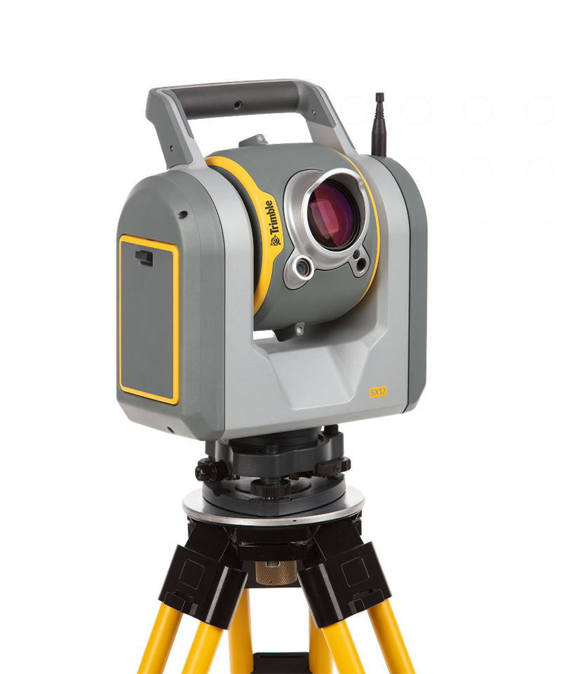
Trimble SX12
Engineered for every day.
By combining innovative technology with intuitive functionality the Trimble® SX12 scanning total station saves time and maximizes efficiency.
Benefits and performance
High accuracy, high quality
The Trimble SX12 total station achieves 1” angular accuracy. This high accuracy is combined with our most precise EDM that produces extremely clean point clouds, saving you time cleaning the data later.


Vivid, eye-safe laser pointer
Aim, measure and mark effortlessly with a vivid green laser pointer with the smallest point size in the industry, just 3 mm at 50 m, that's still eye safe.

Quick data capture
26,600 points per second (scanning) / 1.6 s total station measuring time (prism mode)
Highly accurate
1" angular accuracy & 1 mm + 1.5 ppm prism accuracy
Precise laser pointer
3 mm diameter spot at 50 m
Features and capabilities

Simple navigation & documentation

Field-friendly workflows

Built with Trimble MagDrive

Office software

Industries and applications
The future of your work.
Trimble solutions facilitate high-quality, productive workflows and data exchange, driving value for a global, diverse user base.
Product summary
Trimble SX12
High-accuracy total station with high-precision scanning capabilities.
Product
Specifications
Angular accuracy
1"
EDM accuracy
1.0 mm + 1.5 ppm Prism / 2.0 mm + 1.5 ppm DR
EDM laser spot diameter
14 mm at 100 m
Scan speed
26,600 points per second, 600 m away
Scan range noise
1.5 mm at 200 m
Vivid, eye-safe laser pointer
3 mm diameter spot at 50 m
| Scan speed | Scan Range | Range noise | 3D point accuracy | Scan time | Imaging | Image acquisition time | Interface | Dual axis compensator | Ingress protection | Laser class | |
|---|---|---|---|---|---|---|---|---|---|---|---|
| Trimble X9 Core LTTrimble X9 Core LT | Up to 500 kHz | 0.6 m–40 m | < 1.5 mm @ 30 m on 80% albedo | 3.0 mm @20 m | 2-7 minutes | 3 coaxial, calibrated 10MP cameras | 1-2 min Standard (2-6min HDR) | WLAN via Trimble Perspective Windows tablet or Perspective Mobile from Apple or Android device | Accuracy <3", Range ±10° | IP55 | Laser class 1, eye safe in accordance with IEC EN60825-1 |
| Trimble X9 CoreTrimble X9 Core | Up to 500 kHz | 0.6 m–80 m | < 1.5 mm @ 30 m on 80% albedo | 3.0 mm @20 m | 2-7 minutes | 3 coaxial, calibrated 10MP cameras | 1-2 min Standard (2-6min HDR) | WLAN via Trimble Perspective Windows tablet or Perspective Mobile from Apple or Android device | Accuracy <3", Range ±10° | IP55 | Laser class 1, eye safe in accordance with IEC EN60825-1 |
| Trimble X9 PremiumTrimble X9 Premium | Up to 1000 kHz | 0.6 m–150 m | < 1.5 mm @ 30 m on 80% albedo | 3.0 mm @20 m | 1-6 minutes | 3 coaxial, calibrated 10MP cameras | 1-2 min Standard (2-6 min HDR) | WLAN via Trimble Perspective Windows tablet or Perspective Mobile from Apple or Android device | Accuracy <3", Range ±10° | IP55 | Laser class 1, eye safe in accordance with IEC EN60825-1 |
| Trimble X12Trimble X12 | Up to 2,187 kHz | 0.3 m–250 m; 365 m (Ambiguity Interval) | 0.25 mm @ 25 m (136 kHz) | 2.2 mm @20 m | 1-3 minutes | 80 MP panorama, paralax free image matching | 2-2.5 min (HDR) | Onboard touchscreen or Trimble Perspective on Windows tablet | Accuracy 14", Range ±0.5°, Resolution 0.001° | IP54 | Laser class 1, eye safe in accordance with IEC 60825-1 |
| Trimble SX12Trimble SX12 | 26.6 kHz | 0.9 m–600 m | 1.5 mm @ 50 m on 18-90% reflectivity | 2.5 mm @100 m std dev on sphere target position | 12 minutes | 3 calibrated cameras in telescope powered by Trimble VISION™ technology | 2.5 min Standard | WLAN via Trimble Access | Accuracy 0.5", Range ±5.4', Resolution 0.3" | IP55 | Pulsed laser 1550 nm; Laser class 1M |
Total stations
Trimble SX12
Get in touch for recommendations for the Trimble Geospatial hardware, software, and accessories needed to get your job done.
Request a demoWorks with...

Trimble TSC510
Seamless connectivity, outstanding power and exceptional durability.


Resources and knowledge


Watch what Trimble can do


Deepen your knowledge
Read customer success stories, ebooks, white papers and more.
Next steps
Our global network of Distribution Partners provides precision geospatial solutions, insight and support at a local level.