Trimble and Worldsensing collaborate to expand monitoring solutions with wireless GNSS sensors
Trimble has introduced a new solution for long-term 3D ground and structural movement monitoring that will combine Trimble® 4D Control™ (T4D) monitoring software with the new Trimble GNSS Meter, powered by Worldsensing. This solution augments Trimble's range of geodetic and geotechnical monitoring solutions such as automated total stations, GNSS receivers, dataloggers and tiltmeters.
Designed for the mining, construction and infrastructure industries, this solution helps minimize the risks associated with land and structure instability through the lifetime of a project by enabling faster and more cost-effective deployment for a greater range of project types.
This new monitoring solution will connect the GNSS Meter, powered by Worldsensing, with Trimble T4D monitoring software to automatically transform data into actionable insights. The GNSS Meter is a GNSS sensor featuring RTK technology and the ability to process data directly on the device (Edge processing), providing precise and automated measurement of 3D surface movements once placed onsite. The sensors then transmit data to T4D for real-time analysis and if established thresholds are exceeded, the stakeholders will automatically be alarmed.
The GNSS Meter is designed for scalability, supporting projects of any size by reducing costs and speeding up deployment, making applications that were previously prohibitive now feasible. Paired with T4D, it allows for the seamless integration of additional geodetic and geotechnical sensors as required by project specifications. Its user-friendly setup and intuitive interface enable rapid deployment of numerous sensors with minimal training, significantly reducing time and costs associated with traditional GNSS-based monitoring systems.
Once deployed, the sensors operate automatically, eliminating the need for manual data collection. Leveraging wireless IoT technology, the solution minimizes infrastructure costs by eliminating the need for manual data collection, extensive cabling, while also reducing maintenance expenses.
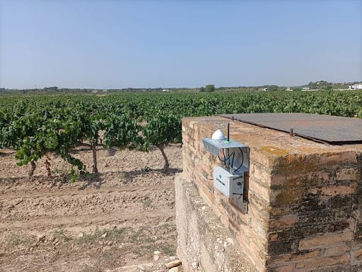
Trimble GNSS Meter on site
Trimble GNSS Meter and T4D: A powerful solution for enhanced safety and risk management
The new GNSS Meter offers precise ground and structural movement monitoring with sub-centimeter accuracy using RTK technology. Its flexible configuration allows nodes to operate as either a base station or rover and it delivers hourly position measurements aggregated over 6 and 24 hours. Measurements are processed in the field and statistics regarding the quality of the position are then transmitted via radio and available in CMT.
Featuring wireless, autonomous and low-power design, the battery-powered devices can last over three years. An integrated tiltmeter and environmental sensors ensure supplementary monitoring data transmission even in challenging conditions. The user-friendly setup and intuitive interface of the GNSS Meter enable the rapid deployment of a high number of sensors with minimal training, making it highly scalable.
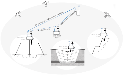 Graphic overview of Trimble GNSS Meter operation
Detecting slow, gradual movements over extended periods is crucial for ensuring safety and minimizing risks, especially in industries such as mining, construction, and civil infrastructure. The new cost-effective and easy-to-install wireless GNSS Meter is ideal for applications like slope stability in open-pit mines, surface subsidence, tailings and embankment monitoring, and areas affected by landslides. One of T4D's main strengths is its ability to configure a wide range of sensors, providing a significant advantage for diverse projects. Additionally, T4D offers application-specific functionalities, such as inverse velocity calculation from real-time or post-processed GNSS data, which have proven invaluable for slope engineers in understanding slope stability.
The ability to cross-check data, such as GNSS and temperature, to gain insights into movement causes is another reason the new GNSS Meter and T4D form a powerful combination, as well as displaying heatmaps from GNSS measurements to understand movement in applications such as landslides. T4D's automated movement detection and real-time reporting capabilities, combined with the precise accuracy of the GNSS Meter, provide comprehensive and reliable insights. This ensures on-site safety and helps minimize the risks associated with land instability throughout a project's lifetime.

Inverse velocity analysis in T4D with GNSS data
Tailored to optimize decision-making and safety
Combining Trimble 4D Control (T4D) software with the new GNSS Meter creates a powerful monitoring solution that significantly enhances decision-making, efficiency, and safety in monitoring workflows. T4D's automated movement detection and real-time reporting capabilities, combined with the GNSS precise sub-centimeter accuracy and advanced edge data processing, provide comprehensive and reliable data that can be trusted. This combined approach delivers the insights necessary for timely and informed decisions, ultimately improving workflow efficiencies and project outcomes.
For more information
To learn more about this new Trimble Monitoring solution, contact your local Trimble Geospatial authorized distributor.