Bringing Data to Life One Point at a Time with Trimble SiteVision Version 5
Capture 3D data more efficiently by combining scanning and precision workflows in a mobile solution.
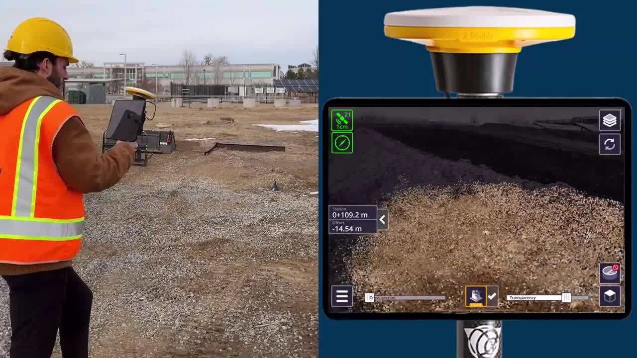
Imagine if you could see things that don’t exist yet. That’s what the Trimble® SiteVision® augmented reality system does—it brings data to life by letting you see and explore 3D models of complex information and designs that are accurately overlaid in the real world and viewed on your mobile device.
Accomplish this with SiteVision software that combines Trimble’s high-accuracy positioning services and cloud-based processing technology, all running on your phone or tablet mounted on a pole, together with the Trimble Catalyst™ DA2 GNSS receiver. In addition to visualization, data can also be captured in the field and shared back to the office via Trimble Connect, a common data environment.
Point cloud collection in the hand
The latest release of Trimble SiteVision (version 5) takes data collection a step further. Combining a LiDAR-equipped Apple iPhone Pro or an Apple iPad Pro* with the Trimble DA2 GNSS receiver, you can now utilize the LiDAR scanning capabilities built into these devices to capture point clouds efficiently and accurately with a single easy-to-use handheld solution.
Field workers can simply walk around the jobsite and as they scan, the captured points are previewed in SiteVision’s augmented reality view. This ensures all the data you need is captured in the field the first time.
And, because the phone’s LiDAR scanner is connected to the DA2 , users can be confident in the quality of the data collected. Every point in the point cloud is automatically georeferenced while connected to the DA2, with no extra work to register it manually back in the office when the data is downloaded for processing in software such as Trimble Business Center or Trimble RealWorks™ office software.
A manhole is scanned and the point cloud pulled into Trimble Business Center for processing
Efficient, fast workflow
The SiteVision LiDAR scanning workflow enables you to:
- Capture photorealistic 3D scans, such as open trenches to document buried services, or recording existing conditions.
- Expand your capabilities. Sometimes it might be too time-consuming to send up a drone or set up a terrestrial scanner. SiteVision provides an easy-to-use and fast reality capture solution with high positional accuracy that is accessible to more people in the field. When you're finished, data is immediately synced to the cloud in seconds at the click of a button. There is no need to export data to and from a USB stick.
- Supplement data captured by traditional scanning processes. Fill in blind spots caused by terrain or equipment that may have been obscured. Or provide coverage in areas inaccessible to drones.
Video showing a field user using Trimble SiteVision to collect a point cloud on a LiDAR equipped iPad Pro device
The SiteVision LiDAR workflow provides users with an accessible and cost-effective way to capture 3D scans quickly and productively.
Trimble SiteVision Version 5 is available now. Contact your local Trimble Distributor for more information, or visit the Trimble SiteVision webpage.
*Android devices do not support LiDAR scanning capabilities.