Self-leveling technology not only streamlines 3D laser scanning operations, especially in challenging terrain, but also provides unparalleled accuracy and dependability.
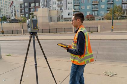
Terrestrial laser scanners that combine an integrated survey-grade servo drive with a swift scanning mirror, facilitating not just auto-calibration but also automatic self-leveling. This significant leap from the traditional manual leveling requirement to an automated system ensures every scan aligns perfectly horizontal, regardless of the ground's unevenness.
Advantages of self-leveling
Automatic self-leveling makes the set-up process incredibly easy. Unlike other scanners, users can put a self-leveling scanner in approximately the right place and the instrument uses LED guide lights to do the rest, rapidly leveling and quickly starting to capture data. Not only does this speed up the process, it makes scanning much more accessible to more people with or without training who can use scanning to gain a business advantage.
Self-leveling scanners make survey-grade accuracy possible without manual intervention, as they are capable of compensating for tilts within ±10° and are suited to uneven terrains like stairs or rugged landscapes — without sacrificing precision.
Impact on data integrity
Self-leveling technology also significantly influences data integrity. During image registration, this feature guarantees uniform reference points across all scans, a critical factor for crafting accurate and cohesive 3D models that inform the quality of the final client deliverable. This uniformity reduces discrepancies that are common during manual leveling, reducing the potential for human error.
User-centric design
Self-leveling technology automates the leveling process and offers visual confirmation of the scanner's level status, bolstering user confidence in the data accuracy. This feature is invaluable in challenging environments where manual leveling could be prone to errors and more time-consuming.
By simplifying a traditionally complex process, self-leveling not only provides high-accuracy scanning across diverse environments but also enhances the quality of data collected, ensuring users' complete confidence in their data capture.
Learn more about self-leveling technology in this white paper.


