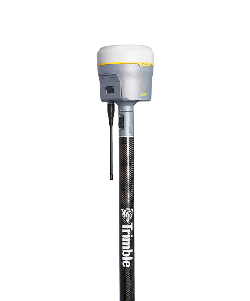
GNSS systems
Trimble R12
Push the boundaries of GNSS performance.
The Trimble® R12 GNSS receiver is engineered for improved performance in challenging GNSS conditions. With groundbreaking signal management and rugged durability, get ready to go further than you ever thought possible.
![geo-product-r12-pim-image](http://images.ctfassets.net/1nvkn1423yot/2w0Qemv2xqnk7YGWNR7dTe/8d01c8033eedb13dc62d8f0d7901a350/geo-r12-productpage-fullbackgroundproducthero-800x960.png)
Benefits and performance
High performance
Boost your productivity with measurably better performance in challenging urban and rural environments, near tree canopy or tall buildings.
![surveyor in a city park with a GNSS rover](http://images.ctfassets.net/1nvkn1423yot/7DFNvTTAxEStf7g9lup8GC/5f6c7a4512a13820b7682a02a2238fc2/geo-r12-productpage-2x2topright-benefits-520x320.jpg)
![surveyor next to a building with a GNSS rover](http://images.ctfassets.net/1nvkn1423yot/ZQGhYXiMghe2OLwWxu2NF/b2bdb34c5c572398eedf9f71602867f4/geo-r12-productpage-2x2bottomleft-benefits-520x320.jpg)
Efficient
Flexible signal management enables the use of all available GNSS constellations and signals. With higher satellite availability, you can get the shot faster.
![r12 in hand](https://images.ctfassets.net/1nvkn1423yot/4qYWpdtPgyv4BvXFqs5unE/d04dd0db88d0925cf192c147aee3861c/geo-r12-productpage-keyfeatures-720x720.jpg?fm=jpg&fl=progressive&w=50&h=50&q=90)
8 mm H/15 mm V
Real-time kinematic precision
672
GNSS channels
2 cm H/5 cm V
CenterPoint RTX precision
Features and capabilities
![Use on your toughest jobs](https://images.ctfassets.net/1nvkn1423yot/4EWj8OuZxBRGnpIrRUKLok/2e611b2ab4a63278e2deccf66365b81d/geo-r12-surveyor-in-forest-unboundedcard-370x247.jpg?fm=jpg&fl=progressive&w=50&h=50&q=90)
Use on your toughest jobs
Provides superior performance and productivity in challenging GNSS environments such as near and among trees and buildings.
![An advanced solution](https://images.ctfassets.net/1nvkn1423yot/168CK7gLOtIvWen8QI4npL/f89fec4591db12a2586b40b8cade1e72/geo-r12-surveyor-in-snow-unboundedcard-370x247.jpg?fm=jpg&fl=progressive&w=50&h=50&q=90)
An advanced solution
R12 is a powerful 672-channel solution with Trimble 360 technology that delivers the most advanced satellite tracking of all constellations.
![Highly accurate, everywhere](https://images.ctfassets.net/1nvkn1423yot/7GOKxqiGaIM7MVN7bAEl6e/052e1d9b8b588dfacd382ad263f0e766/geo-r12-surveyor-on-hilltop-unboundedcard-370x247.jpg?fm=jpg&fl=progressive&w=50&h=50&q=90)
Highly accurate, everywhere
Obtain RTK-level accuracy worldwide without the need for a base station or VRS network with real-time corrections via satellite or internet.
![Keep working during outages](https://images.ctfassets.net/1nvkn1423yot/67OFAAe4wQVYebqPmAec8N/55d0bfe7448fa5891b061e4278824fe6/geo-r12-surveyor-construction-site-unboundedcard-370x247.jpg?fm=jpg&fl=progressive&w=50&h=50&q=90)
Keep working during outages
Reduce downtime in the field with continuous RTK and VRS coverage during correction outages from radio and cellular black spots.
![surveyor by roadside](https://images.ctfassets.net/1nvkn1423yot/3z4tYtdLf9cEJHRn7nnxAX/68422213cf8f621abbb6102739dc8cf5/geo-r12-productpage-industries-2400x730.jpg?fm=jpg&fl=progressive&w=50&h=50&q=90)
Industries and applications
The future of your work.
Trimble facilitates high quality, productive workflows and data exchange, driving value for a global, diverse user base.
Product
Specifications
Real-time kinematic
8 H/15 V mm
CenterPoint RTX
2 cm H/5 V cm
672
GNSS channels
Wideband UHF radio
Up to 2 Watt Tx
Lightweight
1.12 kg
Compact
11.9 cm x 13.6 cm
Skip comparison of 6 items | ||||||||||
Max. Precision | Channels | Antenna | UHF Radio | RTX Compatible | xFill | Memory | Cellular | Satellites | Additional Features | |
---|---|---|---|---|---|---|---|---|---|---|
Trimble R980Trimble R980 | 8 mm H/15 mm V | 672 | Integrated | Receive & transmit 450/900 MHz | Yes | Yes | 9 GB | 4G | GPS, GLONASS, Galileo, BeiDou, NavIC, QZSS, SBAS | ProPoint, TIP Tilt Compensation |
Trimble R12iTrimble R12i | 8 mm H/15 mm V | 672 | Integrated | Receive & transmit 450 MHz | Yes | Yes | 6 GB | 3.5G | GPS, GLONASS, Galileo, BeiDou, NavIC, QZSS, SBAS | ProPoint, TIP Tilt Compensation |
Trimble R12Trimble R12 | 8 mm H/15 mm V | 672 | Integrated | Receive & transmit 450 MHz | Yes | Yes | 6 GB | 3.5G | GPS, GLONASS, Galileo, BeiDou, NavIC, QZSS, SBAS | ProPoint |
Trimble R780Trimble R780 | 8 mm H/15 mm V | 672 | Integrated | Receive & transmit 450/900 MHz | Yes | Yes | 9 GB | External | GPS, GLONASS, Galileo, BeiDou, NavIC, QZSS, SBAS | ProPoint, TIP Tilt Compensation |
Trimble R580Trimble R580 | 10 mm H/20 mm V | 336 | Integrated | Receive 450 MHz | Yes | Yes | 256 MB | External | GPS, GLONASS, Galileo, BeiDou, SBAS, QZSS | ProPoint |
Trimble R2Trimble R2 | 10 mm H/20 mm V | 220 | Integrated | Receive 450 MHz | Yes | No | 48 MB | External | GPS, GLONASS, Galileo, BeiDou, SBAS, QZSS | — |
GNSS systems
Trimble R12
Get in touch for recommendations for the Geospatial hardware, software, and accessories needed to get your job done.
Where to buy![geo-product-r12-pim-image](http://images.ctfassets.net/1nvkn1423yot/2w0Qemv2xqnk7YGWNR7dTe/8d01c8033eedb13dc62d8f0d7901a350/geo-r12-productpage-fullbackgroundproducthero-800x960.png)
Works with...
![Trimble TSC7](https://images.ctfassets.net/1nvkn1423yot/3idy6BlwfYadRtQch9zNvG/7e87a4c88221b3e3aff415b2cc32f7a3/geo-tsc7-boundedcard-272x181.png?fm=jpg&fl=progressive&w=50&h=50&q=90)
![Trimble TSC5](https://images.ctfassets.net/1nvkn1423yot/4rwlPFAzWCVusenbyO62JE/e8a3c8b1f632e1669785c9e6cdbf0b0c/geo-tsc5-boundedcard-272x181.png?fm=jpg&fl=progressive&w=50&h=50&q=90)
![Trimble TDC6](https://images.ctfassets.net/1nvkn1423yot/2mFjkoR9UDKBoR3sqG6fYS/0cee0930bd91e70a4fe356d0bbc12a05/geo-tdc6-boundedcard-272x181.png?fm=jpg&fl=progressive&w=50&h=50&q=90)
![Trimble T7](https://images.ctfassets.net/1nvkn1423yot/15Y3W2ISHJE7Ha0A8mMCdc/6bad2e53c2682da3f62d9e2ca7b24edc/geo-t7-boundedcard-272x181.png?fm=jpg&fl=progressive&w=50&h=50&q=90)
![Trimble S9](https://images.ctfassets.net/1nvkn1423yot/2g6SqR0LlUURyC99mer0jB/9aa10f9c8a83e8131b6038b46f9ae111/geo-s9-boundedcard-272x181.png?fm=jpg&fl=progressive&w=50&h=50&q=90)
![Trimble Access](https://images.ctfassets.net/1nvkn1423yot/41OvHu6gPILXGVqXuU4neu/9081373e0edd71ae206f2605e58e9141/geo-access-boundedcard-272x181.png?fm=jpg&fl=progressive&w=50&h=50&q=90)
![Trimble TerraFlex](https://images.ctfassets.net/1nvkn1423yot/16jX0uUNOVGCVJ0tpIMDIc/25c4dcc99eaa0c2f1f5ecb016a9fb9a5/geo-terraflexfield-boundedcard-272x181.png?fm=jpg&fl=progressive&w=50&h=50&q=90)
![Trimble Business Center](https://images.ctfassets.net/1nvkn1423yot/2J7ibw0ewWiUuMXSGVlnRM/6d0399c409d230009e1689d5c310919f/geo-tbc-boundedcard-272x181.png?fm=jpg&fl=progressive&w=50&h=50&q=90)
Resources and knowledge
![Go beyond the data](https://images.ctfassets.net/1nvkn1423yot/4mX4IpJlmBszW56JXH5aLK/0a700f82280884a97795cdbad4db3fa4/geo-resources-boundedcard1-272x181.jpg?fm=jpg&fl=progressive&w=50&h=50&q=90)
![Inspiring perspectives](https://images.ctfassets.net/1nvkn1423yot/MAOHEc7pfrLCwSYlQWkXa/7823dd85d95b50707428c20fb742bd05/geo-resources-boundedcard2-272x181.jpg?fm=jpg&fl=progressive&w=50&h=50&q=90)
Inspiring perspectives
![Watch what Trimble can do](https://images.ctfassets.net/1nvkn1423yot/6TQWqFBh7v3AzZb70t5D1S/cd9109d57466b367ab07b648290dcaea/geo-trimblex9-productpage-keyfeatures-720x720.jpg?fm=jpg&fl=progressive&w=50&h=50&q=90)
Watch what Trimble can do
![Join us live or later](https://images.ctfassets.net/1nvkn1423yot/7aooMSiWnw5vE8w3c0pv6t/3f1c64a3208dec908d5de204b7df4e2a/geo-resources-boundedcard4-272x181.jpg?fm=jpg&fl=progressive&w=50&h=50&q=90)
Join us live or later
Next steps
Our global network of Distribution Partners provides precision geospatial solutions, insight and support at a local level.