Field software
Trimble Forensics Capture
Guided workflows for efficient scene mapping.
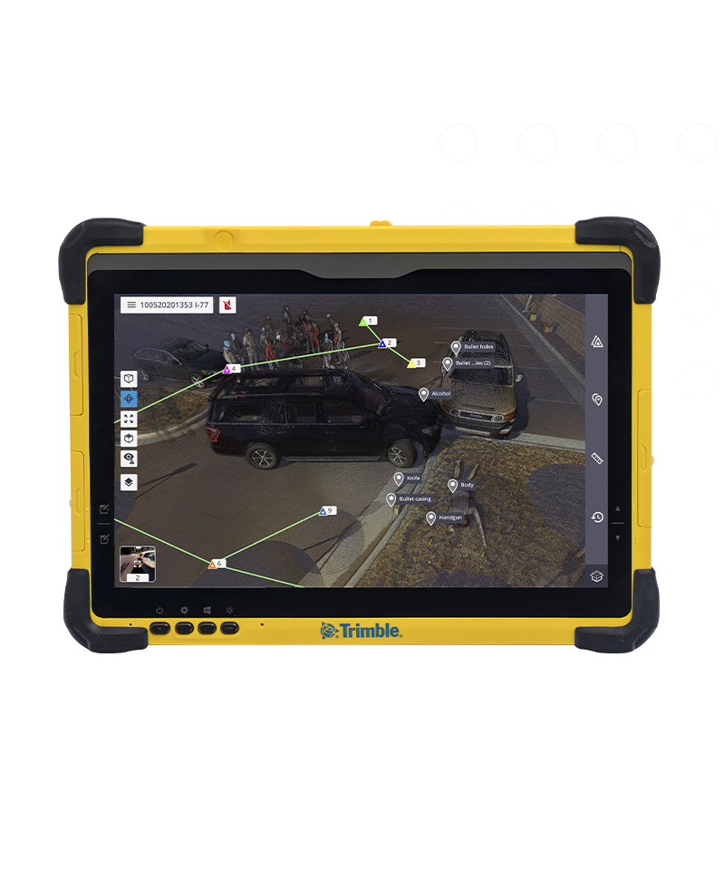
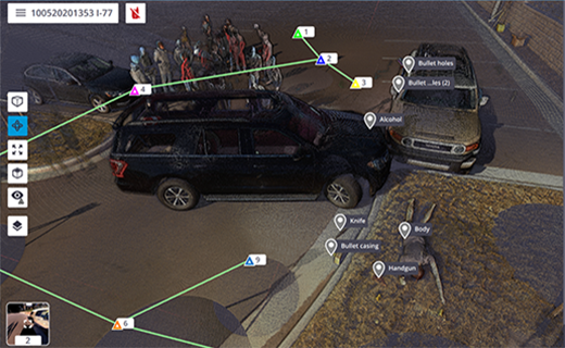
Trimble® Forensics Capture field software is a powerful yet intuitive data collector solution that simplifies scene evidence gathering and enables a seamless transition to Trimble Forensics Reveal desktop software for in-depth analysis.
![geo-product-capture-pim-image](http://images.ctfassets.net/1nvkn1423yot/6S7tQZRhMDTGHSSU8Lfami/65674575366b9d9423f3a340bc1dc0c8/geo-capture-productpage-fullbackgroundproducthero-800x960.png)
Benefits
Smooth and simple workflows
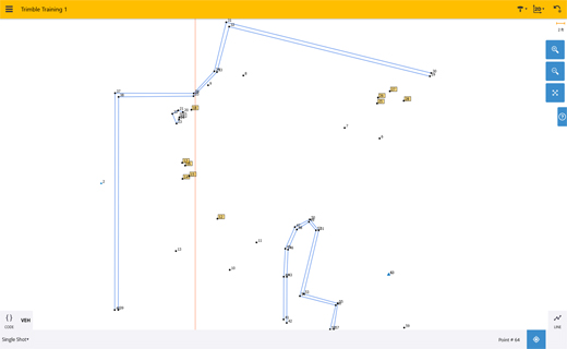
While gathering evidence, see a diagram of your scene as you shoot (in 2D and 3D) from every angle. Zoom in on evidence-rich areas, take notes and more.
![diagram of a scene shot in 3d](http://images.ctfassets.net/1nvkn1423yot/44MJM5QFXS0KkK2pKWNy6h/f1741bc2d92ff2a626422418383e9ced/geo-capture-productpage-2x2benefits-toprightimage-520x320.jpg)
![diagram of a scene](http://images.ctfassets.net/1nvkn1423yot/2bOPrlJUeYWKgDY7BoIu8V/c3d4c8eb2ae5c0f77d422877d69cf333/geo-capture-productpage-2x2benefits-bottomleftimage.png)
Seamless software & hardware integration
Easily collect data with Trimble hardware products and create georeferenced point clouds. Import data into Trimble Forensics Reveal for fast data processing.
![geo-product-capture-subscriptions-image](https://images.ctfassets.net/1nvkn1423yot/37FiswIOkjkA0Q0MSkrUMG/1baec4271769aba85e52cdd5525b56a4/geo-capture-subscriptionplan-superhero-720x720.jpg?fm=jpg&fl=progressive&w=50&h=50&q=90)
Affordable
Lower upfront costs
Flexible
Built around your needs
Up-to-date
Benefit from enhancements
Features and capabilities
![Works with Trimble solutions](https://images.ctfassets.net/1nvkn1423yot/4BjtSqGeqltre6MTXTR8r9/cf4a104a33e8d487dc63a90fb7a53e76/geo-capture-officer-with-t10x-unboundedcard-370x247.jpg?fm=jpg&fl=progressive&w=50&h=50&q=90)
Works with Trimble solutions
Create fully registered and georeferenced point clouds in the field. Full command, control and functionality of GNSS, scanners, and total stations.
![Work the way you want](https://images.ctfassets.net/1nvkn1423yot/4GNh2WxQLwECiRSCvuqBwy/94731f1d12d31c206e187c8fe977286f/geo-capture-officers-on-scene-unboundedcard-370x247.jpg?fm=jpg&fl=progressive&w=50&h=50&q=90)
Work the way you want
Includes fully customizable, built-in point code libraries for effective data organization. Leverage customizable quick code options for rapid data collection.
![Work in 2D or 3D](https://images.ctfassets.net/1nvkn1423yot/4G59t2zWPTi0eGktDwEHEA/45611a57128b8c05fa3ef0a63c7591b5/geo-capture-two-officers-with-r4s-unboundedcard-370x247.jpg?fm=jpg&fl=progressive&w=50&h=50&q=90)
Work in 2D or 3D
Import data collected from another Capture file to collaborate with multiple officers on large scenes or return to old scenes with different hardware.
![Easy and efficient to use](https://images.ctfassets.net/1nvkn1423yot/P95zjqCeIzaIWJpKIkd2y/6a32ecda1c731a0865d49d74459e6525/geo-capture-officer-_with-t10x-and-sx12-unboundedcard-370x247.jpg?fm=jpg&fl=progressive&w=50&h=50&q=90)
Easy and efficient to use
Take advantage of easy-to-manage workflows in the field, then seamlessly transfer data to Trimble Forensics Reveal office software for further assessments.
![officers on scene](https://images.ctfassets.net/1nvkn1423yot/4qxS32u5xYWIejlpHaMYsq/cada1da7fab133661a0f0a51e5128fd4/geo-capture-productpage-industries-fullbackgroundhero-image.jpg?fm=jpg&fl=progressive&w=50&h=50&q=90)
Industries and applications
The future of your work.
Trimble facilitates high quality, productive workflows and data exchange, driving value for a global, diverse user base.
Product summary
Trimble Forensics Capture
Easy-to-use field software for forensics investigators.
Product
Features
Point cloud georeferencing
Create in the field
In-field documentation
Scan all field markers and more
Scanner operation
Remote control or cable
Trimble Registration Assist
Scan data reports and registration
Data interaction
2D, 3D, and station views
Multiple GNSS connection options
RTK, Trimble RTX or base and rover
Field software
Trimble Forensics Capture
Get in touch for recommendations for the Geospatial hardware, software, and accessories needed to get your job done.
Contact us![geo-product-capture-pim-image](http://images.ctfassets.net/1nvkn1423yot/6S7tQZRhMDTGHSSU8Lfami/65674575366b9d9423f3a340bc1dc0c8/geo-capture-productpage-fullbackgroundproducthero-800x960.png)
Works with...
![Trimble R4sLE](https://images.ctfassets.net/1nvkn1423yot/1MbtqUTLOjnjpMv09pyX30/3de3b95a0d1543d9698abd1fda0c17ce/geo-r4sle-boundedcard-272x181.png?fm=jpg&fl=progressive&w=50&h=50&q=90)
![Trimble DA2](https://images.ctfassets.net/1nvkn1423yot/2UTPWGHEQqtwrseQch4T0N/cccb4e06d70fe59c4eca93d0892479e4/geo-da2-boundedcard-272x181.png?fm=jpg&fl=progressive&w=50&h=50&q=90)
![Trimble SX12](https://images.ctfassets.net/1nvkn1423yot/Fvy3B97sCNhYdaLUHMljU/4b37c5ee3dcb80876ac5cf67173f9248/geo-sx12-boundedcard-272x181.png?fm=jpg&fl=progressive&w=50&h=50&q=90)
Trimble SX12
High-accuracy total station with high-precision scanning capabilities.
![Trimble X7](https://images.ctfassets.net/1nvkn1423yot/3cgTdRYx6s4i9oWNtze5mv/d41d90883de3aa181c643b4b5ca304be/geo-x7-boundedcard-272x181.png?fm=jpg&fl=progressive&w=50&h=50&q=90)
![Trimble X9](https://images.ctfassets.net/1nvkn1423yot/20Xykhuwh8zughLUOAtGa0/6312cd877feb45da88ab764c3bab4d88/geo-x9-boundedcard-272x181.png?fm=jpg&fl=progressive&w=50&h=50&q=90)
![Trimble X12](https://images.ctfassets.net/1nvkn1423yot/6ut1CzJlOdlnhHXXI8tQOM/1f24cf66650999a2351c67b19254161d/geo-x12-boundedcard-272x181.png?fm=jpg&fl=progressive&w=50&h=50&q=90)
![Trimble TSC5](https://images.ctfassets.net/1nvkn1423yot/4rwlPFAzWCVusenbyO62JE/e8a3c8b1f632e1669785c9e6cdbf0b0c/geo-tsc5-boundedcard-272x181.png?fm=jpg&fl=progressive&w=50&h=50&q=90)
![Trimble T10x](https://images.ctfassets.net/1nvkn1423yot/7x1bBSXJUXQKr4SAbigh6k/9dfac84ac512d7ee5fd105bdea1b277e/geo-t10xmodel2-boundedcard-272x181.png?fm=jpg&fl=progressive&w=50&h=50&q=90)
![Trimble Perspective](https://images.ctfassets.net/1nvkn1423yot/1IB3CUuWuYUDqET0TTq2RP/8ab7b411c14a6d04817f841cb4764d9d/geo-perspective-perspectiveonST10x-unboundedcard-370x247.jpg?fm=jpg&fl=progressive&w=50&h=50&q=90)
Resources and knowledge
![Go beyond the data](https://images.ctfassets.net/1nvkn1423yot/4mX4IpJlmBszW56JXH5aLK/0a700f82280884a97795cdbad4db3fa4/geo-resources-boundedcard1-272x181.jpg?fm=jpg&fl=progressive&w=50&h=50&q=90)
![Inspiring perspectives](https://images.ctfassets.net/1nvkn1423yot/MAOHEc7pfrLCwSYlQWkXa/7823dd85d95b50707428c20fb742bd05/geo-resources-boundedcard2-272x181.jpg?fm=jpg&fl=progressive&w=50&h=50&q=90)
Inspiring perspectives
![Watch what Trimble can do](https://images.ctfassets.net/1nvkn1423yot/6TQWqFBh7v3AzZb70t5D1S/cd9109d57466b367ab07b648290dcaea/geo-trimblex9-productpage-keyfeatures-720x720.jpg?fm=jpg&fl=progressive&w=50&h=50&q=90)
Watch what Trimble can do
![Join us live or later](https://images.ctfassets.net/1nvkn1423yot/7aooMSiWnw5vE8w3c0pv6t/3f1c64a3208dec908d5de204b7df4e2a/geo-resources-boundedcard4-272x181.jpg?fm=jpg&fl=progressive&w=50&h=50&q=90)
Join us live or later
Want to learn more?
Contact Trimble Geospatial today.