EVEREST Plus: Advanced multipath mitigation
A dominant error source in satellite measurements is caused by a phenomenon known as “multipath.” In the mid-1990s, Trimble introduced the patented Trimble® EVEREST™ multipath rejection technology based on advanced digital signal processing. Within the satellite signal tracking loops, the reflected multipath signals were processed and ultimately rejected. This allowed sub-meter differential global positioning system (DGPS) positioning and faster, more reliable RTK initializations.
The introduction of Trimble Maxwell™ 7 technology, first released in the Trimble R10 model 2 GNSS system in 2018, marks a significant advancement in multipath mitigation performance through a patent-pending technique known as EVEREST Plus. This overview explains the enhancements Trimble receivers offer with this improvement.
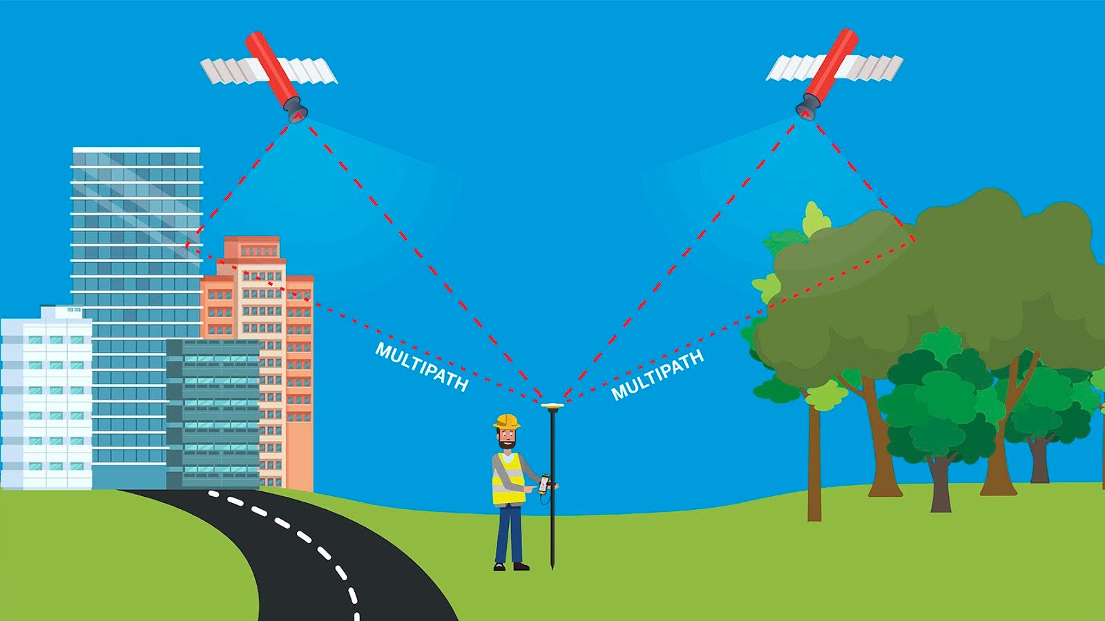
What is GNSS multipath?
Multipath happens when a satellite signal is distorted as it is received by the GNSS receiver on the ground.
Reflective surfaces that can distort GNSS signals are all around us, including metallic surfaces such as vehicles, buildings, water, trees, fences and walls. Multipath can introduce errors of many centimeters in RTK positioning and decimeters or more in autonomous, SBAS or DGPS positioning modes.
What is Trimble doing about GNSS multipath?
EVEREST Plus has several components that contribute to the resulting multipath improvements:
- Improved tracking discriminator, reducing the amount of multipath on the raw measurement
- Extracts additional information from the GNSS receiver to go into the multipath estimator
- Added neural network that takes data from the GNSS receiver and derives an improved multipath estimate, which is removed from the signal it has received
- Improvements in code/carrier filter for a PVT solution to better handle challenging environments, for example, around trees and in built-up urban areas
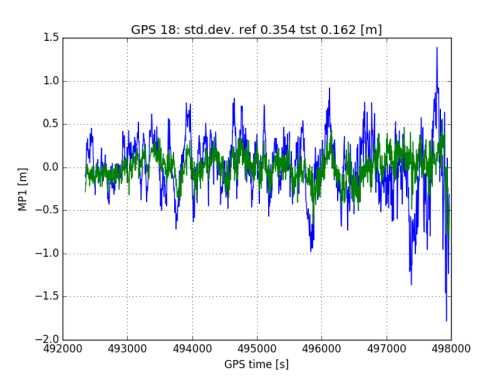
Figure 1
The blue curve in Figure 1 shows the pseudorange multipath on L1 from the mid-1990s EVEREST, versus the green curve showing the multipath from EVEREST Plus. In this example, the multipath reduction is over 50%.
Evaluation of all the GPS constellation satellites from the same data set in a rooftop environment yields an average multipath reduction of 31% with the new EVEREST Plus technique (Figure 2). To evaluate the positioning improvements of EVEREST Plus, dynamic tests were performed and compared to a high-precision GNSS post-processed truth reference.
Data was collected in the following environments:
- Freeway
- Downtown San Jose, California, US
- Open parking lot
- Trimble campus (walking pace)
- Urban

Figure 2
The data was mostly dynamic, but included static sections such as stops at gas stations, traffic lights, stop signs and also covered a variety of traffic speeds. The summary statistics are tabulated below.
Of note, the 2-dimensional position’s 95% confidence interval was improved by 15 to 30%. And sub-meter 95% performance was delivered in all environments except downtown San Jose and the Trimble campus, where the vehicle was driven very close to buildings and trees.
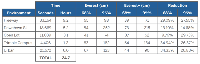
Figure 3: SBAS GNSS-only solution — Horizontal error relative to GNSS/INS forward/backward
While this test focused on SBAS, the DGNSS solution will also benefit, as will the RTK/RTX engine that uses the pseudorange in the initial integer ambiguity search. The original EVEREST technology was only applicable for narrow band GNSS signals. It specifically it operates on:
- GPS & QZSS L1 C/A & L2C
- GLONASS L1 & L2 C/A
- BeiDou B1 & B2
- Galileo E1
- IRNSS L5
With the introduction of EVEREST Plus, this benefit has been extended to the following wideband signals:
- GPS & QZSS L5
- GLONASS L1 & L2 P
- BeiDou B3
- Galileo E5A & E5B
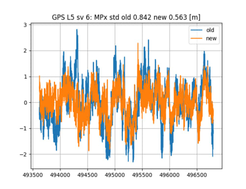
Figure 4
Figure 4 above provides an example of the legacy method of tracking “old” compared to the “new” method of tracking that enables EVEREST Plus. The data was collected on a building roof with a relatively high multipath.
Conclusions
Trimble customers operate in a variety of environments that are subject to multipath effects. This has the potential to reduce the quality and integrity of position and orientations achieved by GNSS receivers.
To prepare for this, Trimble’s precision receivers include EVEREST Plus multipath rejection technology to identify and remove unwanted multipath signals. Users can feel confident with the advanced protection and the accuracy of their high-precision Trimble Maxwell 7-based receivers from Trimble with EVEREST Plus.
Contact your Trimble Authorized Distributor or visit the Trimble website to learn more about Trimble Geospatial GNSS receivers