Streamlining FTTH projects with GNSS and mobile mapping
The deployment of fiber to the home (FTTH) networks is essential for delivering high-speed internet to both urban and rural areas. Achieving this goal requires overcoming numerous challenges, from planning and design to deployment and maintenance. Advanced geospatial solutions are transforming each stage of the FTTH project lifecycle, making the process faster, more efficient and more accurate.
Plan and design
The planning and design phase is critical for identifying the optimal routes and installation points for fiber optic networks. Mobile mapping systems, GNSS and GIS systems and augmented reality software provide precise, real-time geospatial data collection. This data is crucial for efficient fiber infrastructure planning and deployment.

With accurate data, project teams can pre-plan work in the office, minimizing the time spent by contractors in the field and reducing costs. In a recent FTTH project in Loveland, Colorado, US, project management, construction management and civil engineering firm Ditesco was tasked with coordinating contractors and used a combination of mobile mapping and GIS technology
“Rather than having to spend weeks canvassing thousands of properties in each section, we have been able to drive some sections in a single day,” said Joshua Ooms, project engineer with Ditesco, about the use of mobile mapping. “And once processed, we are able to search for images quickly by street and address, look at features from multiple perspectives, and take measurements directly from the images.”
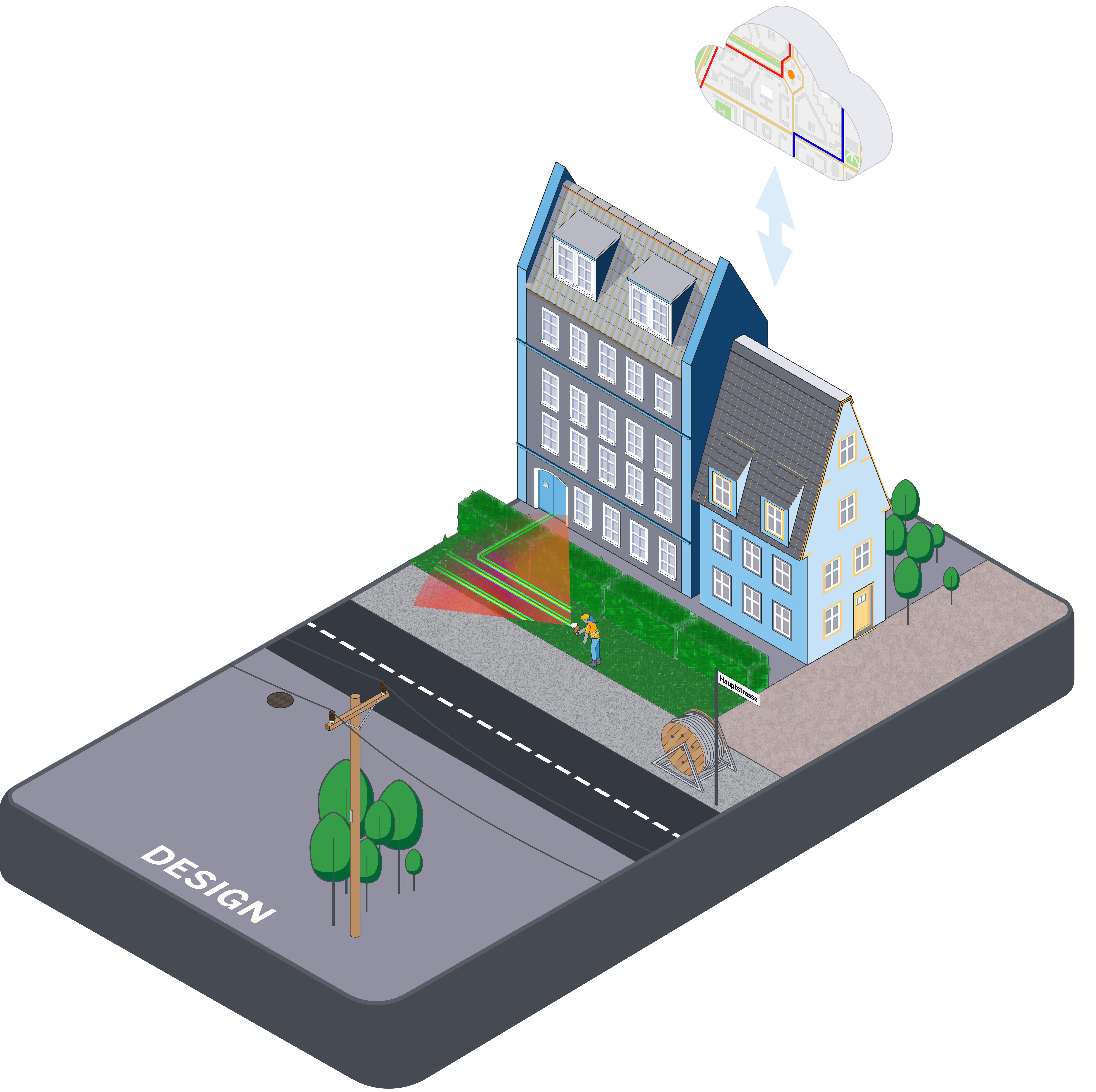
Build and deploy
Deploying fiber optic networks involves installing cables, distribution nodes and other network components. GNSS, LiDAR and augmented reality can be used to ensure precise installation and documentation of the infrastructure.

Ditesco also utilized GNSS rovers to perform as-built surveys of the installed fiber and enclosures. And the team was able to implement an in-the-field workflow where issues are mapped and reported to the respective contractors to fix, streamlining the typical time-consuming punch list process while avoiding expensive change orders.
Ditesco intends to continue using mobile mapping for future FTTH projects, as well as pre-design and as-built surveys for other civil engineering projects.
Operate and maintain
Maintaining an extensive fiber optic network requires accurate records and ongoing monitoring. Software solutions provide a holistic view of the entire environment, enabling seamless integration and expansion of fiber networks.

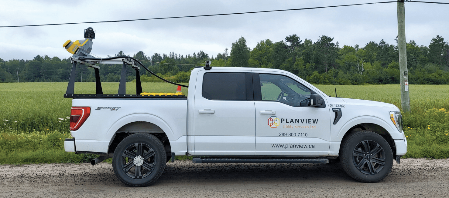
To support and expand the fiber network in Ontario, Canada, Planview Utility Services is collecting thousands of kilometers of location-based information with its mobile mapping system, creating the detailed landbase necessary for effective ongoing planning, design, construction and long-term maintenance of the high-speed fiber optic network all over the province.
“It’s a challenge to get survey teams out to remote areas in our vast province, so we need to minimize the number of field visits,” said Tony D’Amico, Director GIS Services, Solutions & Mobile Mapping at Planview USL. “Mobile mapping allows us to gather a significant amount of data quickly during the summer months.”
“Our Landbase as a Service (LaaS) offering leverages mobile LiDAR to efficiently collect data and provide a comprehensive landbase to our clients to support their design work,” D'Amico continued. “We spend the winter months creating 360-degree imagery with Trimble Business Center and extracting up to 36 layers of data.”
Using an integrated approach, Planview’s collected data can be processed then shared via the cloud, ensuring efficient deployment, minimizing disruptions and supporting the long-term maintenance of the fiber network.
Data management
Effective data management is crucial for leveraging the rich context provided by mobile mapping and GNSS data. Integrated cloud solutions can help facilitate the integration of combined datasets into network planning and management systems, leading to better insights and outcomes.
These advanced tools enable project leads to analyze and disseminate insights throughout massive organizations, optimizing routing and planning maintenance activities more effectively. This data-driven approach ensures that FTTH projects are completed on time, within budget, and to the highest standards.
For more information on how Trimble FTTH solutions can benefit your next fiber network project, visit Trimble FTTH solutions.