Trimble® Reality Capture platform service, designed to streamline data management, visualization and collaboration, makes reality capture workflows more efficient and user-friendly. This innovative service, seamlessly integrated as an extension inside Trimble Connect® cloud software, is available via subscription and empowers surveyors and reality capture professionals to share, collaborate, store and manage massive datasets securely and efficiently in the cloud.
Transforming workflows with powerful cloud technology
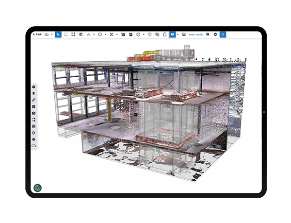
The service delivers a secure and robust cloud-based solution for working with point clouds and 360-degree imagery directly alongside your detailed design data. Professionals in surveying, building construction, transportation and infrastructure can now collaborate on complex projects more quickly and effortlessly, all while maintaining the original accuracy of the data.
Key features:
Enhanced collaboration: Facilitate seamless collaboration with a central source of data for visualization, issue tracking, model comparison, measuring and more, all inside Trimble Connect’s web-based interface
Productivity boosted: Reduce file-based duplication and processing bottlenecks to make massive datasets more actionable
Efficient data management: Streamline workflows for datasets large and small, whether captured via terrestrial 3D laser scanners, mobile mapping systems or UAV platforms
Secure cloud storage: Safeguard your data with a secure, cloud-based platform
Unlocking reality capture data collaboration at scale
Working with Microsoft, the industry leader in cloud computing and storage, Trimble leveraged its deep expertise in reality capture data to deliver workflow improvements for the geospatial and construction industries. This service enhances productivity and decision-making by making data easily accessible and actionable for anyone involved in your projects.
By revolutionizing the use of cloud technology for managing large data packages, the service empowers survey, construction and reality capture professionals to significantly enhance performance and maximize data value. By providing a central source of data, it eliminates collaboration barriers, making it seamless for distributed teams to view, search, download and analyze data. This innovation brings us closer to realizing living digital twins and scalable artificial intelligence applications.
Flexible licensing options
Trimble Reality Capture platform service is available as a subscription service through Trimble Geospatial distribution partners.
Discover more
Learn how you can revolutionize your data management and collaboration processes:
Visit the product page and sign up for a free trial license


