Level up your Trimble Business Center skills with GIS connections and databases
Trimble Business Center (TBC) is a powerful tool for managing and analyzing geospatial data. One of its key features is the ability to connect to and interact with GIS databases. This allows you to bring in data from various sources, edit it, and push it back out to share with others. In this post, we'll explore the basics of GIS connections and databases in TBC.
What is a GIS Database Connection?
A GIS database connection in TBC allows you to directly connect to various GIS data sources, including:
-
Shapefiles
-
File geodatabases
-
Enterprise geodatabases
-
Postgres databases
-
Esri Services
This direct connection allows you to read data from and write data to the GIS database, ensuring your TBC project always has the latest information.
Why is it Important?
Connecting to GIS databases within TBC allows for a more streamlined workflow. Instead of manually importing and exporting data, you can establish a live link to the source. This is especially useful for projects where data is constantly being updated or when working with large datasets.
Setting Up a Connection
To set up a GIS database connection in TBC, you'll need to know a few things:
-
Project Location: Where is your project located, and what coordinate system does it use?
-
Connection Details: How do you connect to the GIS database (e.g., URL, username, password)?
-
Data Needed: Which data from the GIS database do you need for your project?
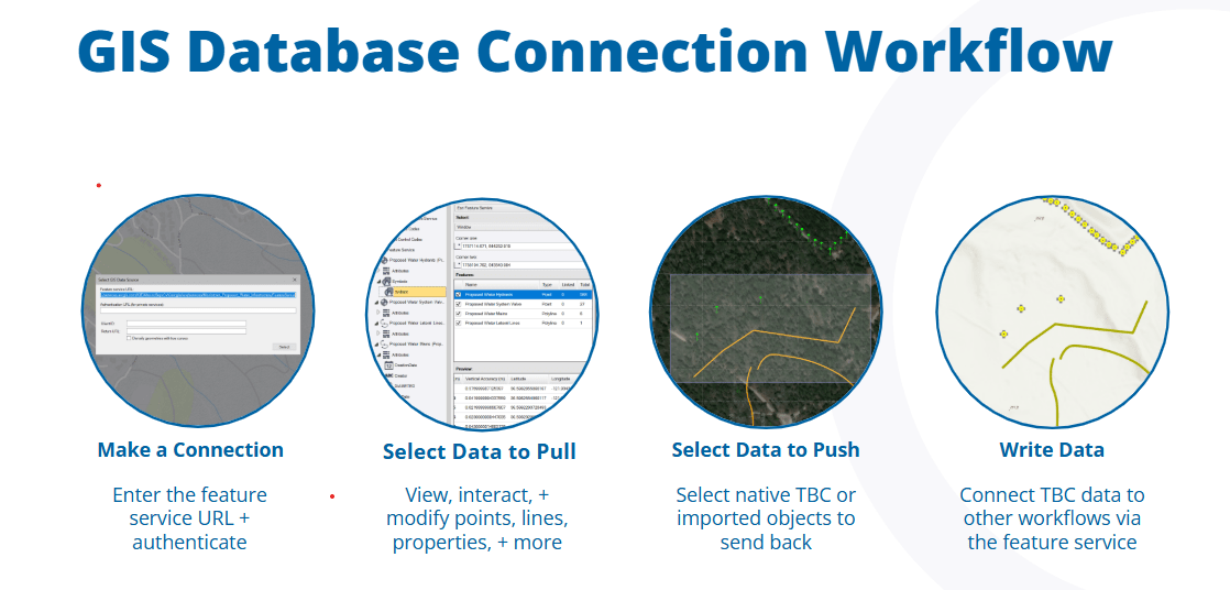
Once you have this information, you can use the GIS Connection Manager in TBC to establish a new connection. You'll need to provide the connection parameters, such as the feature service URL for Esri Services, and authenticate your connection.
Reading Data from GIS
After setting up a connection, you can read data from the GIS database into your TBC project. TBC provides several data selection options to help you reduce the amount of data you import:
-
Window: Select data within a specific window.
-
Layer: Enable or disable entire layers.
-
Polygon: Select data within an existing polygon or draw a temporary one.
-
Filter by attributes (Query): Select data based on specific attribute values.
You can preview your data selection before importing it to ensure you're getting the right information.
Editing and Creating Features
TBC allows you to edit existing features and create new ones directly within the software. You can change the geometry of existing features, correct attributes, or add new information. You can also create new features by collecting geometry, setting feature definitions, and collecting attributes.
Writing Data to GIS
Once you've made changes to your data, you can write it back to the GIS database. TBC allows you to select the data you want to write, check the new or linked feature classes, and generate a report to identify any issues.
Want to learn more about GIS connections and databases in TBC? Check out the 64 new eLearning courses now available on Learn.Trimble.com.
These courses provide a virtual machine environment with the latest TBC version and training datasets, so you can learn without needing a TBC license or installation.
Learn more
Keen to learn more about TBC? We have a range of resources, whether you are new to TBC or a seasoned user. Browse through the TBC YouTube site, visit the TBC Help Portal or contact your local Trimble Distributor.
