Mobile mapping
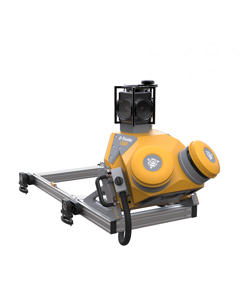
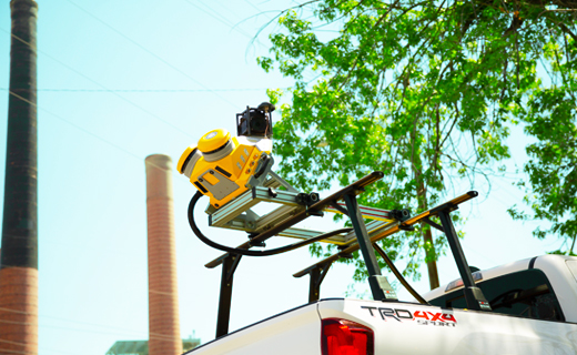
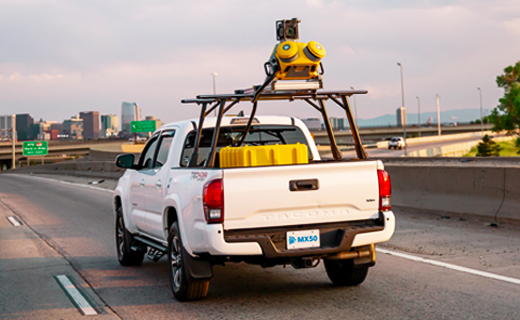
Trimble MX50
Take productivity on the road.
The Trimble® MX50 mobile mapping system delivers accurate point clouds with immersive imagery for easy asset management, mapping and maintenance.
Benefits and performance
Take control of your data capture projects
Effortlessly capture, process, extract and share data with proven field‑to‑finish workflows for asset mapping and asset data management.
Highly productive, yet simple to use
Leveraging state-of-the-art Trimble LiDAR technology, Trimble MX50 delivers accurate data together with immersive imagery and efficient workflows needed for substantial gains in productivity.

Laser effective measurement rate
Up to 960kHz
Spherical camera
30 MP (6 x 5 MP)
Embedded Trimble GNSS-inertial system
Features and capabilities

Quickly obtain asset data

Process vehicle trajectory

High-quality deliverables

Publish & collaborate

Industries and applications
The future of your work.
Trimble solutions facilitate high-quality, productive workflows and data exchange, driving value for a global, diverse user base.
Product summary
Trimble MX50
Mobile scanning and imaging for asset management.
Product
Specifications
Weight
Sensor unit 23 kg
IP Rating
Sensor unit IP64
Spherical camera
30 MP (6 x 5 MP)
Laser effective measurement rate
Up to 960kHz
Scan speed
240 scan/sec
Embedded Trimble GNSS-inertial system
Trimble field-to-finish workflow
| Skip comparison of 4 items | |||||||||||||||||||
| Weight (Sensor Unit) | IP Rating (Sensor Unit) | Operating Temperature | Storage | GNSS Azimuth Measurement System | Distance Measuring Indicator | Spherical Camera | Planar Camera | Laser Scanner | Laser Effective Measurement Rate | Laser Field of View | Scan Speed | Laser Precision | Laser Range Accuracy | Maximum Range, Target Reflectivity > 80% | Minimum Range | Maximum Number of Targets per Pulse | Embedded Trimble GNSS-Inertial System | Field Software | |
|---|---|---|---|---|---|---|---|---|---|---|---|---|---|---|---|---|---|---|---|
| Trimble MX90Trimble MX90 | 37 kg | IP64 | 0 °C to +40 °C | 2 x 4TB SSD removable | Yes, additional | Yes, additional | 72 MP (6 x12 MP) | 2 X 12 MP side facing cameras, 1 X 12 MP backward/downward facing camera | Dual Laser System | 600 kHz, 1 MHz, 2 MHz, 2.5 MHz, 3 MHz, 3.6 MHz | 360° | 500 scan/sec | 3 mm | 5 mm | 475 m (at effective measurement rate 300 kHz) | 1 m @ PRR ≥ 1 MHz, 1.2 m @ PRR < 1 MHz | Up to 15 (at 300 kHz and 500 kHz Laser Pulse Repetition Rate PRR) | X, Y: <0.01 Z: 0.01 | TMI, browser-based, no installation necessary |
| Trimble MX60 CoreTrimble MX60 Core | 20 kg | IP64 | -10 °C to +50 °C | 2 x 4TB SSD removable | Yes, additional | Yes, additional | 30 MP (6 x5 MP) | 1 X 12 MP backward/downward facing camera | Dual Laser System | 1000kHz, 2000kHz selectable | 360° | 200, 400 scans/sec selectable | 1.5 mm | 2 mm | 150m at 1000kHz 120m at 2000kHz | 0.6 m | 1 | X, Y: <0.01 Z: 0.01 | TMI, browser-based, no installation necessary |
| Trimble MX60 ProTrimble MX60 Pro | 22 kg | IP64 | -10 °C to +50 °C | 2 x 4TB SSD removable | Yes, additional | Yes, additional | 72 MP (6 x12 MP) | 1 X 12 MP backward/downward facing camera | Dual Laser System | 1000kHz, 2000kHz selectable | 360° | 200, 400 scans/sec selectable | 1.5 mm | 2 mm | 150m at 1000kHz 120m at 2000kHz | 0.6 m | 1 | X, Y: <0.01 Z: 0.01 | TMI, browser-based, no installation necessary |
| Trimble MX60 PremiumTrimble MX60 Premium | 24 kg | IP64 | -10 °C to +50 °C | 2 x 4TB SSD removable | Yes, additional | Yes, additional | 72 MP (6 x12 MP) | 1 X 12 MP backward/downward facing camera | Dual Laser System | 1000kHz, 2000kHz selectable | 360° | 200, 400 scans/sec selectable | 1.5 mm | 2 mm | 150m at 1000kHz 120m at 2000kHz | 0.6 m | 1 | X, Y: <0.01 Z: 0.01 | TMI, browser-based, no installation necessary |
Mobile mapping
Trimble MX50
Get in touch for recommendations for the Trimble Geospatial hardware, software, and accessories needed to get your job done.
Contact usWorks with...


Trimble Business Center Mobile Mapping

Resources and knowledge


Watch what Trimble can do


Deepen your knowledge
Read customer success stories, study ebooks and white papers, and more.

Want to learn more?
Contact Trimble Geospatial today.