Correction services
Trimble VRS Now
Make reliability your position.
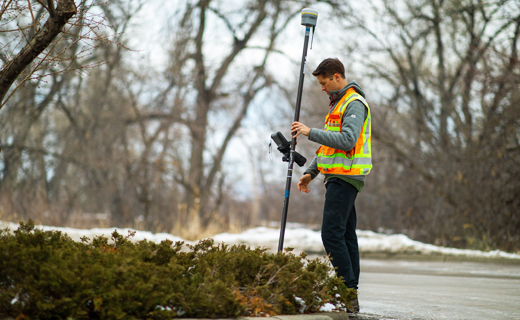
Trimble® VRS Now™ correction service is proven and cost-effective, delivering instant access to network-RTK corrections via cell signal. With around-the-clock, expert monitoring, Trimble-operated Real-Time Kinematic (RTK) networks are a trusted choice for any GNSS survey application.
![geo-product-vrs-now-pim-image](http://images.ctfassets.net/1nvkn1423yot/6QCPPumMCNpCnXLpMba0CR/ab5d96042809540aff47ed48dfbdb12e/geo-vrsnow-productpage-fullbackgroundproducthero-800x960.png)
Benefits and performance
Built in redundancy
Depend on the connectivity and consistency of Trimble VRS Now with added redundancy of the multiple reference stations and around-the-clock network monitoring.
![surveyor on a curb](http://images.ctfassets.net/1nvkn1423yot/3BaHWS7n21TYWsYmo34oF6/555e6124e4ef544deadbd9ea3f895abc/geo-vrsnow-productpage-2x2topright-benefits-520x320.jpg)
![surveying a construction site](http://images.ctfassets.net/1nvkn1423yot/3uCFaY6liiFvVqNlOJizr2/07ced2dea0bc0ec01791346da474624a/geo-vrsnow-productpage-2x2bottomleft-benefits-520x320.jpg)
Tracking full constellations
Work more reliably in challenging GNSS environments. Buildings, trees—and even hills are less of an issue, resulting in more robust data and less vertical error.
![surveyor measuring slope](https://images.ctfassets.net/1nvkn1423yot/5ug35S7EXMgNu8ZctCFPIg/509975b39f2cfbd15c751130cea5d8ad/geo-vrsnow-productpage-keyfeatures-720x720.jpg?fm=jpg&fl=progressive&w=50&h=50&q=90)
High accuracy
2 cm (H) / 3 cm (V) [RMS]
Fast convergence
Start working immediately
Full constellation
GPS, GLO, Gal, BeiDou, QZSS
Features and capabilities
![The best of both worlds](https://images.ctfassets.net/1nvkn1423yot/77w2aV5629opomfMWkRP0k/6c382341b27b6d87f5e7f766dde97648/geo-vrsnow-survey-urban-unboundedcard-370x247.jpg?fm=jpg&fl=progressive&w=50&h=50&q=90)
The best of both worlds
Take “Connect. Correct. Measure.” one powerful step further by layering on the worry-free PPP backup provided by unlimited xFill.
![VRS Now: A true game changer](https://images.ctfassets.net/1nvkn1423yot/4CCslTB2gut8CenxBp64Az/43f6891aba83264b793bf0fbd69be2c1/geo-vrsnow-norway-customer-story-unboundedcard-370x247.jpg?fm=jpg&fl=progressive&w=50&h=50&q=90)
VRS Now: A true game changer
Read details of how this team used VRS Now with no base station and realized significant value with this affordable and simple Trimble solution.
![Because time is money](https://images.ctfassets.net/1nvkn1423yot/6lg0C3J79NwXGLTD95mQCF/f0920ad68b66d5a77875ea2fcd369c65/geo-vrsnow-white-paper-unboundedcard-370x247.jpg?fm=jpg&fl=progressive&w=50&h=50&q=90)
Because time is money
Trimble arms you with an extra layer of redundancy to overcome outliers you may encounter in the field. Plan for the "unexpected" with positioning insurance.
![Trimble RTX backed-up](https://images.ctfassets.net/1nvkn1423yot/6Etq0DQ2IJrB4Qic3kJHvS/5ab692872371198adacc5476a72cb60e/geo-vrsnow-backed-up-customer-story-unboundedcard-370x247.jpg?fm=jpg&fl=progressive&w=50&h=50&q=90)
Trimble RTX backed-up
Discover how this user employed CenterPoint RTX to continue collecting high-accuracy points and avoid downtime when he lost cellular signal in the field.
![outer space](https://images.ctfassets.net/1nvkn1423yot/61NOyIvOQB1eJs0DVvqUFq/0c57c22c8801a26ba64391e26dcf24fe/geo-vrsnow-productpage-industries-2400x730.jpg?fm=jpg&fl=progressive&w=50&h=50&q=90)
Industries and applications
The future of your work.
Trimble facilitates high quality, productive workflows and data exchange, driving value for a global, diverse user base.
Product summary
Trimble VRS Now
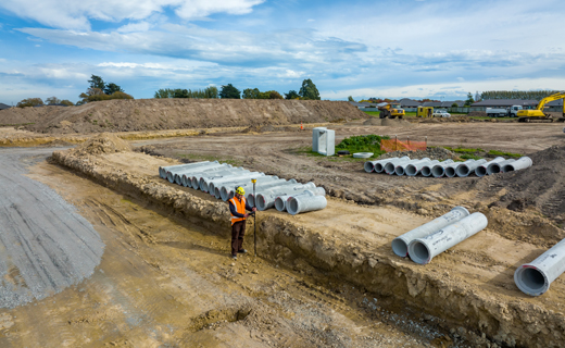
Network-RTK for survey, mapping and construction.
Product
Specifications
Centimeter accuracy via cellular
2 cm (H), 3 cm (V) [RMS]
Available regionally
Europe, North America, APAC
Immediate convergence
No base and no radio required
Easy to use
Cost-effective, ready when you are
Tracking full constellations
GPS, GLONASS, Galileo, BeiDou, QZSS
Providing better uptime
24/7 network monitoring
Skip comparison of 3 items | ||||
Description | Accuracy [Values in RMS] | Delivery | Convergence | |
---|---|---|---|---|
Trimble CenterPoint RTXTrimble CenterPoint RTX | Real-time Precise Point Positioning (PPP) | 2 cm(H)/3 cm(V) | Satellite and internet | <1 min in select regions / <3 min worldwide for ProPoint devices |
Trimble VRS NowTrimble VRS Now | Real-time network positioning | 2 cm (H) / 3 cm (V) | Internet | Immediate when you connect to the server |
Trimble xFillTrimble xFill | Your real-time correction + Trimble RTX positioning insurance | Maintains centimeter-level accuracy | Satellite and internet | Always on and ready if your RTK connection drops |
Correction services
Trimble VRS Now
Get in touch for recommendations for the Geospatial hardware, software, and accessories needed to get your job done.
Where to buy![geo-product-vrs-now-pim-image](http://images.ctfassets.net/1nvkn1423yot/6QCPPumMCNpCnXLpMba0CR/ab5d96042809540aff47ed48dfbdb12e/geo-vrsnow-productpage-fullbackgroundproducthero-800x960.png)
Works with...
![Trimble R980](https://images.ctfassets.net/1nvkn1423yot/1ZZKEddgzg1wnyQpeXN67H/55c5870b8f67dba50a4c2a7b6deba717/geo-product-r980-primary-card-image-272x181.png?fm=jpg&fl=progressive&w=50&h=50&q=90)
![Trimble R12i](https://images.ctfassets.net/1nvkn1423yot/2UVSR7JwzVmyugBxVWjBCo/1ad02430188555542e21fd06f5371c1d/geo-r12i-boundedcard-272x181.png?fm=jpg&fl=progressive&w=50&h=50&q=90)
![Trimble R12](https://images.ctfassets.net/1nvkn1423yot/4r7HHyVwsvigLRlYnsNy2m/a19d882ce7a19d3c0594efb7a47b58cf/geo-r12-boundedcard-272x181.png?fm=jpg&fl=progressive&w=50&h=50&q=90)
![Trimble R780](https://images.ctfassets.net/1nvkn1423yot/2POj0SYpZkVHRGa18ZfkKB/6dbacb312336a97125fd65f87338c0c7/geo-r780-boundedcard-272x181.png?fm=jpg&fl=progressive&w=50&h=50&q=90)
![Trimble R750](https://images.ctfassets.net/1nvkn1423yot/68qryA4krbhERVt6exWLmc/e904793018ca6ff81385eea91cb5ae8e/geo-r750-boundedcard-272x181.png?fm=jpg&fl=progressive&w=50&h=50&q=90)
![Trimble R2](https://images.ctfassets.net/1nvkn1423yot/5n0VOObfs9DJrzNo02hKy4/0f35494a6de1f1283c53d7846cfe8756/geo-r2-boundedcard-272x181.png?fm=jpg&fl=progressive&w=50&h=50&q=90)
![Trimble Catalyst](https://images.ctfassets.net/1nvkn1423yot/2gqaL6oU6zsOrv1k8toany/9c3fe06cd12e1dbf06cd78cbf29509c9/geo-catalyst-boundedcard-272x181.png?fm=jpg&fl=progressive&w=50&h=50&q=90)
![Trimble DA2](https://images.ctfassets.net/1nvkn1423yot/2UTPWGHEQqtwrseQch4T0N/cccb4e06d70fe59c4eca93d0892479e4/geo-da2-boundedcard-272x181.png?fm=jpg&fl=progressive&w=50&h=50&q=90)
Resources and knowledge
![Go beyond the data](https://images.ctfassets.net/1nvkn1423yot/4mX4IpJlmBszW56JXH5aLK/0a700f82280884a97795cdbad4db3fa4/geo-resources-boundedcard1-272x181.jpg?fm=jpg&fl=progressive&w=50&h=50&q=90)
![Inspiring perspectives](https://images.ctfassets.net/1nvkn1423yot/MAOHEc7pfrLCwSYlQWkXa/7823dd85d95b50707428c20fb742bd05/geo-resources-boundedcard2-272x181.jpg?fm=jpg&fl=progressive&w=50&h=50&q=90)
Inspiring perspectives
![Watch what Trimble can do](https://images.ctfassets.net/1nvkn1423yot/6TQWqFBh7v3AzZb70t5D1S/cd9109d57466b367ab07b648290dcaea/geo-trimblex9-productpage-keyfeatures-720x720.jpg?fm=jpg&fl=progressive&w=50&h=50&q=90)
Watch what Trimble can do
![Join us live or later](https://images.ctfassets.net/1nvkn1423yot/7aooMSiWnw5vE8w3c0pv6t/3f1c64a3208dec908d5de204b7df4e2a/geo-resources-boundedcard4-272x181.jpg?fm=jpg&fl=progressive&w=50&h=50&q=90)
Join us live or later
![colorized image of a large bridge near a dam](https://images.ctfassets.net/1nvkn1423yot/2ltDqiRXmUJQAvDWpKKVwx/30365c8a263a8fa2bc9ea99af8dd1e62/geo-vrsnow-productpage-pullquote-640x640.jpg?fm=jpg&fl=progressive&w=50&h=50&q=90)
Next steps
Our global network of Distribution Partners provides precision geospatial solutions, insight and support at a local level.