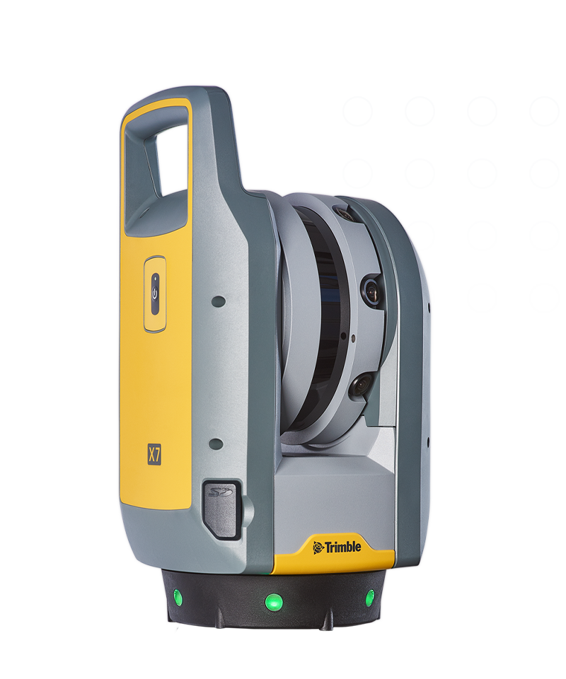
Laser scanning
Trimble X7
Powerful performance made simple.
The high-speed Trimble® X7 3D laser scanning system delivers fast and accurate results every time for surveyors and geospatial professionals. Take this compact and easy-to-use scanner anywhere with confidence.
![geo-product-x7-pim-image](http://images.ctfassets.net/1nvkn1423yot/IhbcmzSeLhLJxZHvk5pRO/92f97faea4dde7e229fe71c685b5ed03/geo-x7-productpage-fullbackgroundproducthero-800x960.png)
Benefits and performance
Automatic calibration
Sending in your laser scanner for calibration is a problem of the past; automatically detect any issues in real time, guaranteeing performance and accuracy.
![Trimble X7 next to a Gas Pipeline](http://images.ctfassets.net/1nvkn1423yot/2dKQyU4UxQZhkpMvnzfZ3L/14282a716b633ad029e795ebe606e532/geo-x7-productpage-2x2topright-benefits-520x320.jpg)
![Trimble X7 and Tablet](http://images.ctfassets.net/1nvkn1423yot/3nqNN6poLXg0g83nyAOInI/c20dd43b3afb455398f8c7cbe2582d16/geo-x7-productpage-2x2bottomleft-benefits-520x320.jpg)
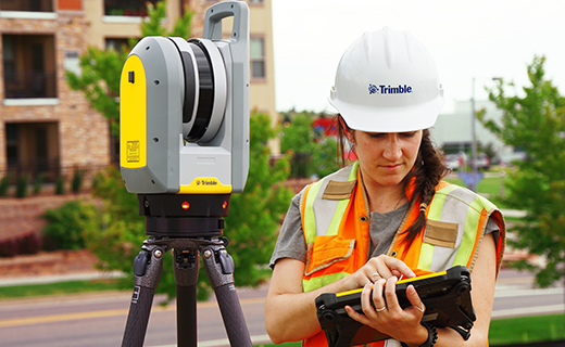
Streamlined software workflows
Fully integrated with Trimble Perspective software for comprehensive registration workflows to accomplish more in the field.
![Man capturing real time data](https://images.ctfassets.net/1nvkn1423yot/2kAgY51DvY4CjQVXKvc3t5/18242f60648f2b1cce1bb99b037e8b3a/geo-x7-productpage-keyfeatures-720x720.jpg?fm=jpg&fl=progressive&w=50&h=50&q=90)
Scan speed
Up to 500 kHz
Scan Range
0.6–80 m
Scan time
<2 min to 15 min
Features and capabilities
![Breakthrough innovations](https://images.ctfassets.net/1nvkn1423yot/6Cd3u9koVzj6wRwRdfK8fx/00ae8f36d5ef1f2e676adb610b5d6b28/geo-x7-under-bridge-unboundedcard-370x247.jpg?fm=jpg&fl=progressive&w=50&h=50&q=90)
Breakthrough innovations
![Reality capture for the real world](https://images.ctfassets.net/1nvkn1423yot/Cbs8goCn2edDQ1OsYMLIu/b1759469778b5fa2962031c0c9506580/geo-x7-against-blue-sky-unboundedcard-370x247.jpg?fm=jpg&fl=progressive&w=50&h=50&q=90)
Reality capture for the real world
![Intuitive & powerful](https://images.ctfassets.net/1nvkn1423yot/2t1qvWcPYU1aMU5QvcgU1U/f7c48427729158b277943be27d738dde/geo-x7-surveyors-collaborating-unboundedcard-370x247.jpg?fm=jpg&fl=progressive&w=50&h=50&q=90)
Intuitive & powerful
![Complete scanning solution](https://images.ctfassets.net/1nvkn1423yot/7yDh10QoeLAamFAY9P2bOz/d06c580aaa87aec9518c5cddea2ac6ce/geo-trimblex7-realworks-office-software-unboundedcard-370x247.jpg?fm=jpg&fl=progressive&w=50&h=50&q=90)
Complete scanning solution
![Trimble X7 by a lake](https://images.ctfassets.net/1nvkn1423yot/4aXVrV4vzrNO7ItNx50z1U/2b1e50125b96809ff3c1d6cd2be4fc59/geo-x7-productpage-industries-2400x730.jpg?fm=jpg&fl=progressive&w=50&h=50&q=90)
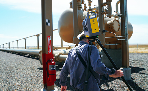
Industries and applications
The future of your work.
Trimble facilitates high quality, productive workflows and data exchange, driving value for a global, diverse user base.
Product summary
Trimble X7
Innovative technology and simple workflows for all users.
Product
Specifications
Scan speed
Up to 500 kHz
Scan range
0.6 m–80 m
Scan times
< 2 min to 15 min
Auto-calibration
No targets or user interaction for accuracy on every scan
Self-leveling
<3" with tilt compensation range of ±10°
Environmental protection
IP55
Operating temperature
-20°C to +50°C (–4°F to 122°F)
Ease of use
Intuitive Trimble Perspective workflows
Skip comparison of 4 items | |||||||||||
Scan Speed | Scan Range | Range Noise | 3D Point Accuracy | Scan Time | Imaging | Image Acquisition Time | Interface | Dual Axis Compensator | Ingress Protection | Laser Class | |
---|---|---|---|---|---|---|---|---|---|---|---|
Trimble X7Trimble X7 | Up to 500 kHz | 0.6 m–80 m | < 2.5 mm @ 30 m | 3.5 mm @20 m | 2-7 minutes | 3 coaxial, calibrated 10MP cameras | 1-2 min Standard (2-6min HDR) | WLAN via Trimble Perspective Windows tablet or Perspective Mobile from Apple or Android device | Accuracy <3", Range ±10° | IP55 | Laser class 1, eye safe in accordance with IEC EN60825-1 |
Trimble X9Trimble X9 | Up to 1000 kHz | 0.6 m–150 m | < 1.5 mm @ 30 m on 80% albedo | 3.0 mm @20 m | 1-6 minutes | 3 coaxial, calibrated 10MP cameras | 1-2 min Standard (2-6 min HDR) | WLAN via Trimble Perspective Windows tablet or Perspective Mobile from Apple or Android device | Accuracy <3", Range ±10° | IP55 | Laser class 1, eye safe in accordance with IEC EN60825-1 |
Trimble X12Trimble X12 | Up to 2,187 kHz | 0.3 m–250 m; 365 m (Ambiguity Interval) | 0.25 mm @ 25 m (136 kHz) | 2.2 mm @20 m | 1-3 minutes | 80 MP panorama, paralax free image matching | 2-2.5 min (HDR) | Onboard touchscreen or Trimble Perspective on Windows tablet | Accuracy 14", Range ±0.5°, Resolution 0.001° | IP54 | Laser class 1, eye safe in accordance with IEC 60825-1 |
Trimble SX12Trimble SX12 | 26.6 kHz | 0.9 m–600 m | 1.5 mm @ 50 m on 18-90% reflectivity | 2.5 mm @100 m std dev on sphere target position | 12 minutes | 3 calibrated cameras in telescope powered by Trimble VISION™ technology | 2.5 min Standard | WLAN via Trimble Access | Accuracy 0.5", Range ±5.4', Resolution 0.3" | IP55 | Pulsed laser 1550 nm; Laser class 1M |
Laser scanning
Trimble X7
Get in touch for recommendations for the Geospatial hardware, software, and accessories needed to get your job done.
![geo-product-x7-pim-image](http://images.ctfassets.net/1nvkn1423yot/IhbcmzSeLhLJxZHvk5pRO/92f97faea4dde7e229fe71c685b5ed03/geo-x7-productpage-fullbackgroundproducthero-800x960.png)
Works with...
![Trimble Perspective](https://images.ctfassets.net/1nvkn1423yot/1IB3CUuWuYUDqET0TTq2RP/8ab7b411c14a6d04817f841cb4764d9d/geo-perspective-perspectiveonST10x-unboundedcard-370x247.jpg?fm=jpg&fl=progressive&w=50&h=50&q=90)
![Trimble Perspective Mobile](https://images.ctfassets.net/1nvkn1423yot/4vf6U7DLFd6qSer7qcYIGJ/10749c179c2b3ffc04ec4f1e4103f7c9/geo-perspectivemobile-unboundedcard-272x181.png?fm=jpg&fl=progressive&w=50&h=50&q=90)
Trimble Perspective Mobile
![Trimble RealWorks](https://images.ctfassets.net/1nvkn1423yot/7B9jgAtBvPJGxTnm9GNkCB/6f0c90fb70c5804d6688f3d5a2869067/geo-realworks-boundedcard-272x181.png?fm=jpg&fl=progressive&w=50&h=50&q=90)
![Trimble Business Center](https://images.ctfassets.net/1nvkn1423yot/2J7ibw0ewWiUuMXSGVlnRM/6d0399c409d230009e1689d5c310919f/geo-tbc-boundedcard-272x181.png?fm=jpg&fl=progressive&w=50&h=50&q=90)
![Trimble T10x](https://images.ctfassets.net/1nvkn1423yot/7x1bBSXJUXQKr4SAbigh6k/9dfac84ac512d7ee5fd105bdea1b277e/geo-t10xmodel2-boundedcard-272x181.png?fm=jpg&fl=progressive&w=50&h=50&q=90)
![Trimble T100](https://images.ctfassets.net/1nvkn1423yot/4hMVyT7HoyI2isHjyvlfBn/8d52e10d85a0f8e8853abab3ceb7b965/geo-t100-boundedcard-272x181.png?fm=jpg&fl=progressive&w=50&h=50&q=90)
Resources and knowledge
![Go beyond the data](https://images.ctfassets.net/1nvkn1423yot/4mX4IpJlmBszW56JXH5aLK/0a700f82280884a97795cdbad4db3fa4/geo-resources-boundedcard1-272x181.jpg?fm=jpg&fl=progressive&w=50&h=50&q=90)
![Inspiring perspectives](https://images.ctfassets.net/1nvkn1423yot/MAOHEc7pfrLCwSYlQWkXa/7823dd85d95b50707428c20fb742bd05/geo-resources-boundedcard2-272x181.jpg?fm=jpg&fl=progressive&w=50&h=50&q=90)
Inspiring perspectives
![Watch what Trimble can do](https://images.ctfassets.net/1nvkn1423yot/6TQWqFBh7v3AzZb70t5D1S/cd9109d57466b367ab07b648290dcaea/geo-trimblex9-productpage-keyfeatures-720x720.jpg?fm=jpg&fl=progressive&w=50&h=50&q=90)
Watch what Trimble can do
![Join us live or later](https://images.ctfassets.net/1nvkn1423yot/7aooMSiWnw5vE8w3c0pv6t/3f1c64a3208dec908d5de204b7df4e2a/geo-resources-boundedcard4-272x181.jpg?fm=jpg&fl=progressive&w=50&h=50&q=90)
Join us live or later
![geo-product-x7-mag-tianhong-surveyor-image](https://images.ctfassets.net/1nvkn1423yot/2tsSqcijlJvetCeS8msMP7/85d67a84063b912c9b5ecd75ae83ccd7/geo-x7-productpage-pullquote-640x640.jpg?fm=jpg&fl=progressive&w=50&h=50&q=90)
Next steps
Our global network of Distribution Partners provides precision geospatial solutions, insight and support at a local level.