Office software
Trimble Business Center
Field-to-finish survey CAD software.
Trimble® Business Center (TBC) software enables surveyors to transform field data from GNSS receivers, total stations, laser scanners, mobile mapping systems, drones and more into high-quality, actionable information and client deliverables.
Benefits
Powerful workflows for superior results
From the industry-leading GNSS baseline processor to dynamic surfaces, point cloud classification and feature extraction, optimize your data and deliverables.
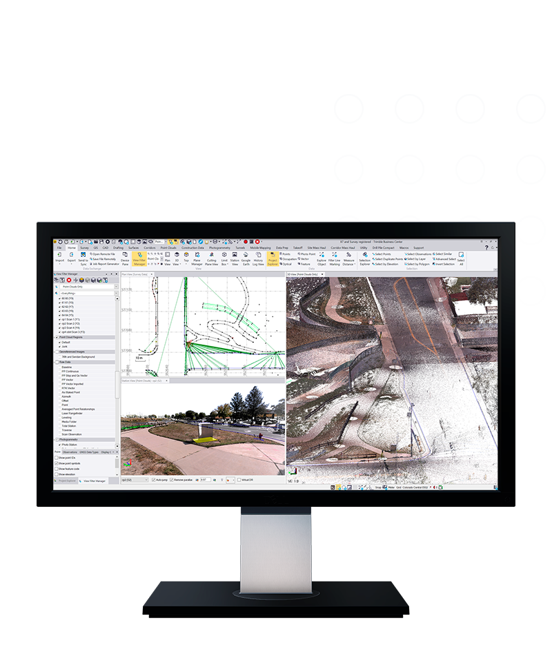
View & adjust raw data in one software
Eliminate unnecessary data exports, correct field blunders, reduce rework and ensure data traceability in a single application.

Affordable
Lower upfront costs
Flexible
Built around your needs
Always up-to-date
Benefit from enhancements
Features and capabilities

Work with data, not coordinates
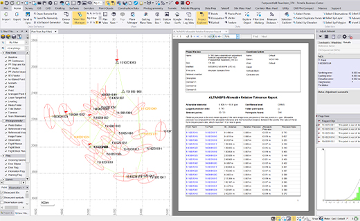
Review and adjust metadata like rod heights and vector quality, and then refine your raw observations with a least squares routine or GNSS post-processing. Plus, leverage new cloud-level coordinate systems and project templates to ensure consistent settings and data synchronization between the field and office instantly.

Support all survey sensors
Bring your GNSS, total station, digital level, terrestrial scan, UAV, mobile mapping and machine control data into one project environment. You can also publish massive terrestrial and mobile mapping point clouds directly to the Trimble Connect 3D viewer for frictionless web-based streaming and collaboration.

Report & share results
Work across standard industry hardware formats. Then, connect your project to software providers such as ESRI, Autodesk, Bentley and more, all within a modernized, low-friction interface designed to reduce visual clutter and mental fatigue.

Report, create, export & more
Start and stay in TBC with options like adjustment reports, digital surfaces, classified point cloud regions, constructible corridors and third-party exports. Now featuring AI-driven feature extraction and automated reporting to let the software do the heavy lifting and speed up your deliverables.

Industries and applications
The future of your work.
Trimble solutions facilitate high-quality, productive workflows and data exchange, driving value for a global, diverse user base.
Product summary
Trimble Business Center
Field-to-finish survey CAD software.
Product
Features
Data prep
Create constructible models
Field data adjustment
Reduction and post-processing tools
GIS
Link attributes & geometry to Esri
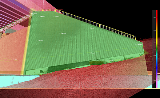
Point clouds & scanning
Extract info and classify regions
Surfaces
Dynamically link & update
Takeoff
Quantities for planning & payment
TBC software modules include a range of workflows to meet diverse project needs.
Trimble Business Center
Aerial Photogrammetry
Aerial survey and mapping projects from fly to finish.
TBC Aerial Photogrammetry software supports third-party UAV raw data and features a streamlined adjustment workflow designed for surveyors to create colorized point clouds, orthomosaic images and raster elevation maps.
Trimble Business Center
GIS
GIS interoperability for survey workflows.
TBC delivers comprehensive tools for survey and GIS schema and data interoperability. Connect your survey workflows with leading software like Esri ArcGIS for seamless GIS integration.
Trimble Business Center
Mining
Robust software for mine surveying.
Trimble Business Center (TBC) Mining office software delivers tools for mine and quarry survey workflows. By calculating volumes and tracking progress and optimizing operations, TBC Mining software equips professionals with streamlined tools for confident decision-making.
Trimble Business Center
Mobile Mapping
Mobile mapping field-to-finish workflows with confidence.
Turn rich Trimble mobile mapping point cloud and image data into actionable information. Leverage the dense and detailed data collected from Trimble mobile mapping systems across CAD, measurement, classification, segmentation and extraction tools in TBC.
Trimble Business Center
Monitoring
Field-to-finish monitoring workflows with confidence.
Bring designs, survey and monitoring data together in one software, reducing the need to manage large and complex spreadsheets for monitoring projects. Automate report creation and remove the need to manually manage data.
Trimble Business Center
Roading
Parametric tools to translate linear infrastructure designs into constructible models.
Review cross-sections, superelevations, and elevation tables while building alignment-based templates and linework for staking and as-builts in the field.
Trimble Business Center
Tunneling
Complete office software for tunnel surveys.
TBC Tunneling software provides a full feature set for professionals to build tunnel models for construction and translate them into field setouts, create as-built models and generate reports.
Office software
Trimble Business Center
Get in touch for recommendations for the Trimble Geospatial hardware, software, and accessories needed to get your job done.
Request a demoWorks with...


Trimble Business Center GIS
TBC GIS integrates survey and GIS data, enabling seamless data exchange and efficient workflows.

Trimble SX12
High-accuracy total station with high-precision scanning capabilities.


Resources and knowledge


Watch what Trimble can do


Deepen your knowledge
Read customer success stories, ebooks, white papers and more.

Want to learn more?
Contact Trimble Geospatial today.